By Jim Ward, IAC 12127
Among the U.S. Pilot community Aerobatic Practice Areas (APA) are perhaps the least-known among FAA-designated Miscellaneous Activity Areas with the National Airspace System (NAS) 1. This paper introduces APAs, their purpose and how FAA informs NAS users about them today. It advocates for improving pilot awareness of this airspace in order to step up safety for APA users and non-participants alike.
Aerobatic Practice Areas: Why and What
Federal Aviation Regulations permit aerobatic flight in most Class E and G airspace above 1,500 feet. 2. That's a sufficient floor for most aerobatically-inclined pilots, though not for all. Airshow pilots, for example, practice—and are tested—at the minimum altitudes they'll fly in their performances. Developing and maintaining the "sight picture" at such low altitudes is essential to flying safely.
Aerobatic competition pilots are similarly situated. Rules for competitions sanctioned by the International Aerobatic Club and CIVA permit maneuvering at heights as low as 328'.
Pilots flying aerobatics at these altitudes, or under other conditions prohibited by FAR, operate under the terms of an FAA waiver. Airspace subject to such a waiver is an Aerobatic Practice Area. 3
Between one and two hundred Aerobatic Practice Areas exist throughout the United States today.
APA Sites
Each APA is situated at a fixed location and bounded laterally and vertically. APAs vary in shape and height. The lateral bounds of some form a circle, others, a rectangle, and a handful, irregular polygons. Low height limits range from the surface to 1,500'; high limits often run to 5,000'. 4
Several considerations factor into APA placement. Safety—for people and objects on the surface as well as users—is paramount. Topography and noise figure prominently, too. Subtler factors include:
• having an underlying, surveyed and/or marked competition box
• the presence of natural surface features or man-made objects to identify boundaries meaningful to users
• proximity to an airport, to accommodate unexpected situations requiring a safe, speedy return
• surface accessibility by vehicle for ground observers
• distance from federal airways
APA users are responsible to see and avoid traffic, like all other VMC operators within the NAS. Each FAA waiver often imposes further obligations on users, such as advance notification of the TRACON responsible for the airspace, requirements for weather minima exceeding basic VFR and monitoring/announcing on the CTAF of an adjacent airport.
Most APAs are adjacent to airports or a short distance away. While they don't influence runway safety, they do affect pattern safety and warrant non-participating pilots' attention. A few cases illustrate why:
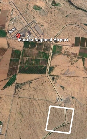
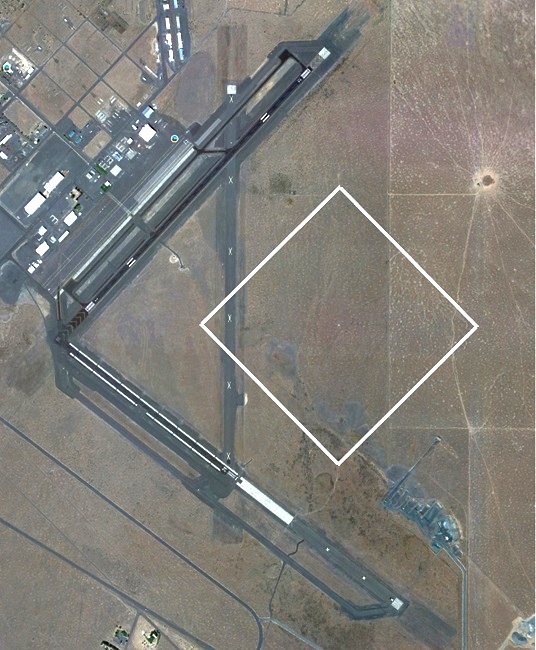
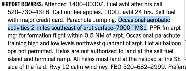
• At Marana, AZ, (upper right) the APA is a 1 kilometer/side square centered about 2 miles SSE of the runway 30 threshold. It overlies a surveyed, permanently marked competition box. Anyone departing toward the prominent quarry south of the airport flies through, as do pilots (mistakenly) flying left traffic for runway 30.
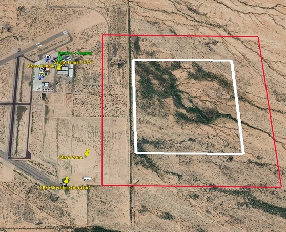
• The Coolidge, AZ APA lies over and adjacent to airport property east of runways 17-35. Underneath is a competition box, now unmarked. Arrivals via a crosswind for runway 5 fly through, as do any departures making an early turn eastward over the airport. (middle right)
• The Ephrata, WA APA and marked competition box lies overhead the airport. Here, the traffic pattern is moved to the west and south sides of the field for all runways while the APA/box is in use. Transiting pilots occasionally fly through, off CTAF frequency, en route to or from the nearby
VOR. Now and then, landing pilots accustomed to east-side traffic for runways 3, 11 and 21 join the pattern before making a radio call and learning the APA is active. (lower right)
VOR. Now and then, landing pilots accustomed to east-side traffic for runways 3, 11 and 21 join the pattern before making a radio call and learning the APA is active. (lower right)
Vigilance by APA users is essential to safety. At airports like these, participants announce their APA usage on CTAF, then monitor the frequency and scan for traffic while maneuvering. If present, ground observers—often other pilots serving in a coaching or critiquing role—also look for traffic; they report
potential conflicts to the user by radio.
APA traffic conflicts requiring a resolving action are common; near-misses and collisions are not. Deconfliction usually involves the APA user returning to straight-and-level flight and a course or altitude change by one or both pilots. A ground observer can point out conflicts by radio to facilitate resolution.
For APAs near airports, the CTAF often provides the APA user advance notice to be extra vigilant for traffic.
A missing link in the APA safety equation is the non-participating pilot. Though APA locations and altitudes are available to every NAS user, they're difficult to find, interpret and apply. Equipping nonparticipants with readily accessible APA locations and altitudes would increase awareness, vigilance and
safety.
Locating APAs Today: A Challenge for NAS Users
Ideally, APA locations and attributes would be available to NAS users in a form ready to use for flight planning and operations. FAA has been working together with stakeholders from the NAS community for over ten years to move in that direction.
Information published to NAS users today to locate APAs appears mostly in Chart Supplements and sporadically on VFR charts.
Chart Supplements identify about 100 APAs in the United States. Here's a sampling of how they're described:
1. Many appear in the "Special Notices" section as prose descriptions.
2. Others are identified in the "Airport Remarks" section for nearby airports, such as this one for Marana, AZ (KAVQ):
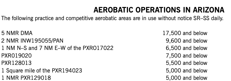
3. Several Arizona APAs appear in a "Special Notices" table that describes locations using VOR radials and distances. Shapes and sizes are included for some.
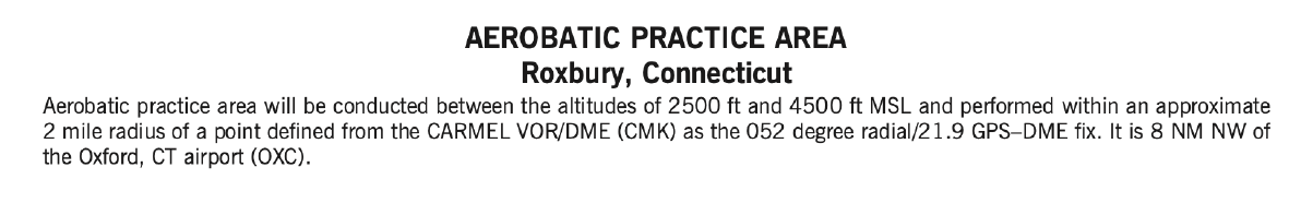
4. Occasionally, a Special Notice describes an APA graphically and textually.
Using Chart Supplements alone to locate APAs along a planned route is, at best, tedious and difficult. In rare instances,
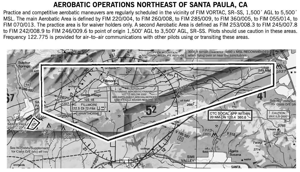
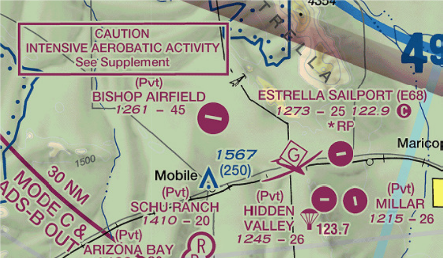
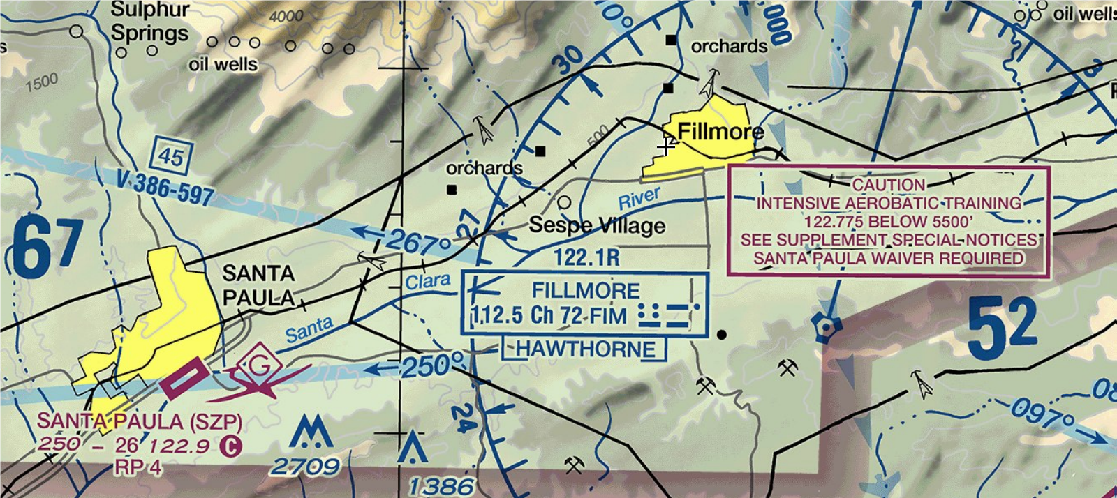
VFR charts provide a text notice of an APA; these callouts near Maricopa, AZ and Santa Paula, CA correspond to Chart Supplement graphical and textual descriptions:

In 2015, FAA established a distinct chart symbol to mark APAs on Sectional, Terminal Area, Helicopter and VFR Flyway Charts.
At publication time, this symbol identifies one APA northwest of Chicago; it is not deployed at a dozen others spot-checked by the author. (pictured right)
Improving APA Awareness for Non-Participating Pilots
An opportunity to improve APA safety exists today by leveraging techniques already deployed for other Miscellaneous Activity Areas, particularly Parachute Jump Areas.
Regulators publishers, and other stakeholders might consider:
• Prioritizing deployment of the APA visual chart symbol throughout the NAS.
• Creating map data for popular EFBs that depict APA boundaries and altitude limits, akin to what
some EFB providers publish for PJAs.
• Establishing and applying a uniform template to describe APAs in Chart Supplements.
• Improving teaching and recurrency curricula to include an equivalent level of content for APAs as
is done for other types of Miscellaneous Activity Areas.
Greater APA awareness for non-participants yields heightened vigilance, fewer traffic conflicts between participating and non-participating aircraft, and a safer environment for all airspace users.
The author is a longtime aerobatic competitor, flight instructor and APA user. He lives in Seattle and Tucson. Reach him at james.roger.ward@gmail.com. Views expressed are his.
___________________________________________________
Foot Notes:
1 Parachute Jumping Areas and Glider Operating Areas, which FAA also designate as Miscellaneous Activity Areas, have been charted for decades.
2 All altitudes are feet AGL except those within Chart Supplement excerpts; those are MSL unless labeled otherwise.
3 Aerobatic competition boxes are distinct from APAs and omitted from this paper. Competition boxes are temporary and require issuance of a Class I NOTAM. Given their operational requirements, conflicts by non-participants are rare, monitored by multiple ground personnel and readily resolved.
4 Practice areas used by jets have higher upper limits.